Search:
Powered by
Website Baker
Big Blue Battlefield
Self-guided Walking Tour
The Battle of the Big Blue was actually two separate engagements, one taking place on Saturday, October 22 and the other taking place on Sunday, October 23, 1864. On both days Confederate and Union cavalry fought each other to gain control of the Byram’s Ford crossing on the Big Blue River. Both these actions were part of a larger series of engagements over a three day period referred to as the Battle of Westport. The Battle of Westport was the climax of the 1864 cavalry expedition through Missouri led by Confederate General Sterling Price. The Battle of Westport was the largest battle west of the Mississippi River that occurred during the American Civil War. It was also a decisive victory for the Union. For these reasons, some have given the battle a nickname, “The Gettysburg of the West."
The fighting from October 21 through October 23 occurred over 100 square miles of territory in west central Missouri. Most of the battlefield has been consumed by the Greater Kansas City metropolitan area. Since 1983, the Monnett Battle of Westport Fund has been working to preserve a small, but very important, part of the battlefield at the site of Byram’s Ford on the Big Blue River. The result is the Big Blue Battlefield Park, which is located in Kansas City, Missouri just north of Swope Park. It is not your typical city park with swing sets and tennis courts.
This section of the Big Blue Battlefield was added to the National Register of Historic Places in 1989. The Monnett Fund continues to restore and interpret this part of the battlefield. This self-guided tour interprets those areas of the battlefield accessible today by car and by foot. The tour focuses on the events that occurred at Byram’s Ford on Sunday, October 23. Defending the ford was the Confederate division commanded by Major General John S. Marmaduke. Advancing on the ford from Independence was the Provisional Cavalry Division from the Department of the Missouri and under the command of Major General Alfred Pleasonton.
 |
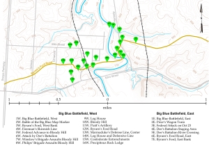
You should be able to complete this tour in a single morning or afternoon. It’s designed to be a walking tour. You drive to a starting point on the east side of the Big Blue River and then walk to various tour stops on the battlefield. After completing these tour stops, you drive to another starting point on the west side of the Big Blue River and then walk to additional tour stops.
As long as you follow the directions, this tour takes place on the Big Blue Battlefield Park, property owned by the Monnett Battle of Westport Fund, property owned by the City of Kansas City, or street rights of way.
The walking tour on the east side of the river has seven tour stops and is moderate in difficulty. The length of the walking tour on the east side of the river is about one mile. The total change in elevation is probably around 300 feet, although it does not all happen at the same time. You will be walking up and down a lot. This part of the tour is all “off road” on part of the original historic Byram’s Ford Road and a series of hiking trails.
The walking tour on the west side of the river has 16 tour stops and is also moderate in difficulty. The length of the walking tour on the west side of the river is about three miles. The total change in elevation is probably around 300 feet, again not all happening at the same time. This part of the tour is a combination of walking on paved roads, the original historic Byram’s Ford Road, and hiking trails.
The walking trails have been cleared of brush, but the ground is uneven in places so be sure to wear sturdy shoes or boots. And anytime you go for a hike in Missouri woodlands, you need to take proper precautions for mosquitos, chiggers, ticks, and poison ivy.
A number of the tour stops are located in the flood plain of the Big Blue River. You should avoid these locations if the river is over its banks
Since this is a new tour, many of the tour stops have been marked with temporary signs attached to thin, orange fiberglass poles, about three feet tall. Over time, we hope to get more permanent markers in place.
For each tour stop, we have included a link to Google Maps. If you have Internet connectivity, this link will jump to Google Maps and show a push pin for the tour stop. You can view Google Maps in street view or with satellite images. If you have Google Earth installed on your computer, you will be able to download a link to kmz files which you can open using Google Earth.