Search:
Powered by
Website Baker
Tour Stop, “Dee's Battalion”
This tour stop consists of two physical locations. At first you will walk down into the ravine used by the 150 or so men of Captain Edward W. Dee’s Battalion from the Fourth Iowa Cavalry to approach the Big Blue River. Then you will follow the ravine down to the Big Blue River just as Dee’s Battalion did. One obstacle you have to deal with is Hardesty Avenue, which cuts across the ravine. The road wasn’t there in 1864 so your approach to the river will be a bit more difficult, physically, than it was for the men in Dee’s Battalion.
Dee’s Battalion Staging Area
[Waypoint = 39.020733, -94.520883]
Dee’s Battalion River Crossing
[Waypoint = 39.020550, -94.522167]
Directions and Description
|
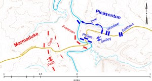
Map showing movements of Dee's Battalion on October 23, 1864 by theCivilWarMuse based on USGS 1935 Kansas City Quadrangle (Click map for larger image) |
Colonel Edward F. Winslow detached the Third Battalion, Fourth Iowa Cavalry, commanded by Captain Edward W. Dee and sent it down the hill into this ravine to anchor the Federal right. According to their maps, there was a ravine that Dee’s Battalion could follow all the way to the Big Blue River. There the Third Battalion could get across the river and attack the Confederate left flank. There is another tour stop on the west side of the Big Blue Battlefield to see where Captain Dee began his attack from the west bank after crossing the river.
You get to Dee's Battalion Staging Area by following the Dee’s Battalion Trail (marked with yellow paint) into the ravine to the northwest of your current location. It’s a 350 yard hike of moderate difficulty over uneven ground. You will experience an approximate change in elevation of 100 feet from the top of the hill down into the ravine.
|
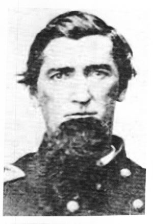
Abial R. Pierce courtesy of the Battle of Westport Museum |
Return to and walk back down the Historic Byram’s Ford Road. About halfway down to Hardesty Avenue, you should see a path on the right that heads north. The trail starts just about where the Bram’s Ford Road begins its steep descent. It is marked with one of those temporary signs attached to thin, orange fiberglass poles, about three feet tall.
Follow the trail (marked by yellow flags and yellow paint on the trees) down into the bottom of the ravine until you reach the location for Dee’s Battalion Staging Area. This position is located next to a very large sycamore marked with two yellow paint dots. Look for one of those thin orange poles.
Now that you have reached the bottom of the hill, you are standing in the ravine used by Dee’s Battalion to move west to the Big Blue River. Take a look around and notice the vegetation in the ravine. In 1864, this ravine was similarly filled with trees, although the undergrowth may not have been as thick as it is today. So it’s easy to see why Dee’s Battalion was not observed as it moved into the ravine and towards the Big Blue River. From this position, take note of the culvert that passes under Hardesty Avenue following the path of the ravine. When you get to the west side of Hardesty, you will be able to see the other end of this culvert.
Dee's Battalion River Crossing is on the opposite side of Hardesty Avenue from your current location. The construction of Hardesty Avenue filled in part of the ravine. From your position, you can see the culvert that passes under Hardesty Avenue following the path of the ravine. This culvert goes the length of the ravine, exiting at the river on the other side of Hardesty Avenue. You are going to climb up to Hardesty, a change in elevation of about 20 feet, and then cross over to the other side.
When you’re ready, follow the trail west to Hardesty Avenue. From the bottom of the ravine, it’s a short climb up to the road. When you reach Hardesty, light pole number 1550 should be just to your right (north). Then cross the road and follow the hiking trail back down into the ravine. Watch carefully for any traffic before crossing over to the west side of the street. Follow the trail down into the bottom of the ravine and then northwest to the river until you see another one of the temporary markers, a thin, orange pole. It’s about 120 yards from Hardesty, and the change in elevation down to the river bank is about 35 feet. When you reach the river bank, you are in the approximate location where Dee’s Battalion crossed to the west side.
Historical Vignettes
Major Abial R. Pierce, commanding Fourth Iowa Cavalry, wrote about sending Dee’s Battalion to the right.
"The Third Battalion of the Fourth Iowa, under Captain [Edward W.] Dee, which had been watching during the night, was concentrated and sent to the right, with orders to wade the stream and effect a lodgment on the other bank."
|
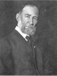
William F. Scott from Roster of the Fourth Iowa Cavalry by Scott |
Sergeant William F. Scott, Fourth Iowa Cavalry, wrote about the enemy opening fire on the Federals as they moved into position to attack.
"Before [our] dispositions were completed the enemy opened, from the bushes and felled trees on the opposite side of the river and from a higher position farther back, a hot fire of small-arms and artillery … On our side of the stream were abrupt hills one hundred feet high. The only road to the ford descended by a long slope along the rocky face of one of these hills, against which the bullets were incessantly pattering. The stream was two hundred yards in front and south of this hill. The dismounted Missouri cavalry cautiously approached the brow of the hill and rushed down the road to the river. Then Captain Dee, with the Third Battalion of the Fourth Iowa, approaching by a deep wooded ravine on the right of the road, dashed into the stream, among the rocks and fallen trees, and after some exciting exposure, reached the other bank and held the ground. At this moment Philips’ Missouri regiment, near the river, stopped and threw themselves upon the ground. They had lost a few men, and found the rebel fire too severe. Winslow rode down the hill to the water, and again ordered them to charge across, upon the first rebel line on the other side, calling their attention to the success of Captain Dee and his men, who were already on the other side."


